
The first attempt at traffic calming on Madison Avenue met with something less than unanimous support.
City engineers hope a new project to improve safety on the street – where crossing pedestrians and speeding vehicles often find themselves in conflict – will be better received.
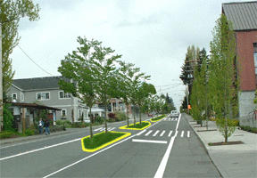
The public works department this week unveiled a plan to construct as many as four “islands” for pedestrian refuge in the center turn lane, with crosswalks at those and several other points on Madison and High School Road.
“They’re strategically placed so they make sense, and they’re where people want to go,” engineer Lorenz Eber said of the improvements.
In 2000, an experimental calming project saw the realignment of the traffic lanes from Winslow Way to Wyatt Way, with pylons and planters intended to show where sidewalks might be extended and on-street parking added.
The department received more than 500 comments on the three-month project, many of them distinctly unflattering.
Particularly unhappy were local motorists, many of whom said the realignment was unsafe as they tried to reach downtown or the ferry terminal.
“People really disliked the chicaning and the road meandering around,” Eber said.
Even city officials conceded that the project was not properly engineered; in some cases the new radii at intersections were too small for trucks and other large vehicles to turn.
But the project did have its fans, particularly those on foot who found it easier to cross the expanse of 45 feet of asphalt that stretches between Madison Avenue’s curbs.
From those comments, Eber said, came the current plan.
Four islands are proposed, one each in front of the Island Health and Fitness gym, city hall, the Big Star Diner and near the north entrance to the Pavilion.
The islands would be similar to those that flank the entrances to the Madison Avenue roundabout, albeit longer and wider. The curbing would narrow the travel lanes by two feet to slow vehicles down.
The larger islands would include landscaping and as many as 14 trees total, possibly with irrigation systems built in to keep the flora watered during the summer months.
“Landscaping will be a big issue,” Eber said. “Dead trees will not be tolerated there.”
Also, following new design standards that have been introduced nationally, the portion of the crosswalks within the islands would be angled slightly, directing the view of pedestrians toward oncoming vehicles.
Total project cost is estimated at $75,000, with funds already in the public works budget for pedestrian improvements this year.
The plan has already been reviewed by the city council’s public works committee. Eber said the department hopes to expedite the comment process, with a goal of getting construction under way sometime this summer.
High School Rd.
Changes would also come to High School Road under the proposal to meet ongoing complaints among pedestrians and motorists there.
First, a new pedestrian island would be added west of the main Safeway driveway, to accommodate residents of the Virginia Villa apartments and others.
Residents in that complex, many of them senior citizens, have long complained of unsafe conditions at the current sidewalk in front of American Marine Bank, with pedestrian-vehicle mishaps reported.
An island in front of the M&M Market and Deli down the street would be expanded and landscaping added, while conditions around the problematic intersection at Hildebrand Lane next to the Village Chevron would also be changed.
There, a triangular pedestrian island would be constructed at High School Road.
The change would still allow vehicles leaving Hildebrand to turn right or left onto High School Road, but would improve the “channelization” of vehicles that now enter the intersection almost at random. Those on foot would also find refuge in an improved crosswalk.
The project comes as the city begins an initiative to design “streetscapes” that will guide future improvements on Winslow-area roadways.
Peter O’Connor, one of two architects behind that planning effort, said the plan for pedestrian islands doesn’t necessarily mesh with that effort, and hoped to resolve that question with the mayor.
But the streetscape work as yet has no timeline associated with it. Eber said the improvements he’s proposing “could probably last a long time,” but aren’t necessarily intended to.
“It can be viewed as ‘disposable,’ if it’s disliked or some bigger, grander plan comes along,” he said.
