Neighbors offer vision for Strawberry Plant
Published 3:23 pm Tuesday, September 30, 2008
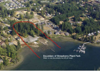
On a sunny day it looks simple enough – a 4.2-acre parcel of wooded public land nestled among residential neighborhoods on the north shore of Eagle Harbor.
Viewed on a city planner’s map, Strawberry Plant Park is crawling with complexity.
A 150-foot freshwater buffer rings a creek that trickles down the property’s eastern edge from its headwaters at a detention pond in an upland neighborhood. From critical wetland areas along its shoreline, a series of concentric shoreline stretch inland, leaving only a patch along the property’s western boundary free for high-impact development.
A long history of industrial use, remembered in foundations, debris and pilings scattered on the site, adds layer of cultural concern.
With those confines in mind, 29 members of the public still found room for creativity during a four-hour charrette Saturday, when they tried their hands at laying out how a future Strawberry Plant Park might look. A rough consensus from the designs showed a park that would emphasize natural restoration and low-impact uses, including walking trails, picnic tables and non-motorized boating.
A few, including long-time islanders Jerry Elfendahl and Dave Ullin, shared their vision for a more active park, which could include a boat haulout and a building for woodworking and crafts.
City planners were looking for input as they draft plans for future use of the property, which will eventually be turned over to the Bainbridge Metro Park and Recreation District. Results from the charrette will be posted online for public comment.
The city acquired Strawberry Plant in 2004 in a land swap deal brokered by the Open Space Commission, with an eye on both environmental restoration and parkland. The city entered a formal agreement to jointly develop the property with the park district.
The city’s Shoreline Stewardship Program is taking the lead on the environmental aspects and the park district focusing on recreational opportunities.
“The charrette was really an opportunity to look at the park and rec end of things,” said Peter Namtvedt Best, a city shoreline planner.
The city invited more than 150 islanders, mostly residents of surrounding neighborhoods, but also members of stakeholder-interested groups – including the Land Trust, Historical Society, Suquamish Tribe and trails groups.
After an introduction to the park, residents were divided into five groups, equipped with a map of the property and tracing paper and asked to sketch their own visions for the park. Under the squeaking of markers, trails appeared, bridges were constructed, pilings were yanked, pavement was pulverized and five different parks emerged.
When the groups presented their work, common elements were easy to find.
All supported restoration of shorelines and native vegetation to varying degrees. All had trails twining through the property, connecting to park to the waterfront trail and surrounding neighborhoods. And most included a bridge over the creek along with kiosks highlighting the park’s ecological and historic elements.
Launching for kayaks, row boats and other non-motorized boats was incorporated in all designs and one group included a campsite for paddlers. The idea of tearing out the central pad of concrete and replacing it with a lawn or meadow for picnics and games was also popular.
Some groups said pilings should be removed with the exception of a few for bird nests. Some supported keeping the artificial peninsulas on the site as viewing areas.
Parking proved a difficult aspect of the design. A paved roadway already serves as an entrance to the site, but providing parking and a turn around for vehicles would take up much of the area where high-impact use is allowed. Most groups preferred to keep parking off the site, but many neighbors didn’t like the idea of park-goers crowding neighboring streets.
Elfendahl and Ullin offered a minority opinion, proposing a “working waterfront” park.
They suggested the creation of a community crafts center where residents could practice woodworking and shipwright skills, as well as areas for small boat storage, a float for boats to tie to and a place to haul boats out of the water to be worked on.
“We don’t have another site on the island where we can do this, period,” Elfendahl said.
Best said aspects of those plans, especially the boat haulout, wouldn’t be possible on the site under existing shoreline restrictions.
“It may be a great idea, but it’s not allowed under the regulations,” Best said. “That’s something that without a code change couldn’t happen.”
After input from the broader public is gathered, the consensus on recreation at Strawberry Plant will be combined with restoration plans already in development to form a comprehensive design for the park.
The city has so far landed two grants for restoration; one from the state Salmon Recovery Fund, the other from Natural Resource Damage Assessment Council, which is allocating funds generated from fines from the Wyckoff Superfund site across the bay. The city has brought Anchor Environmental on board to conduct an analysis of the site.
Best said elements considered so far for habitat restoration would include removal of bulkheads and digging out the artificial peninsulas to restore tidelands. The creosote-treated pilings would be removed but some concrete pilings would be kept for bird habitat.
To a large extent, the parameters of the grants will dictate the restoration side of the project, but Best said there is some room for public input and flexibility.
Box: A report from the Strawberry Plant charrette will be made available Oct. 5 on the city website at xxxxxx.ci.bainbridge.us. Comments will be taken for 14 days after the report is posted.