A vision for Island Center on Bainbridge Island includes more trails and pathways to make it easy for people to get around on foot or by bicycle without cars.
It also envisions better access to Fletcher Bay, and a city park with a platform that would provide a view of the bay.
The current draft plan would only allow new residential development as part of a mixed-use project, meaning the development would need to include commercial development as well.
The Island Center Subarea Planning Process Steering Committee has released its draft plan. Once finished it will go to the Planning Commission and eventually to the City Council.
Jon Quitslund, a liaison from the Planning Commission, said housing has been a “sticking point. “There’s been vocal opposition to very much housing,” he said, adding they do want the housing to be affordable. They want to create a framework to developing housing gradually, not “mushrooming overnight.”
He said there also has been a “cautious” approach to commercial growth, adding they don’t want to become another Lynwood Center. They are willing to have a “measured amount” of commercial growth.
Quitslund said committee member Michael Loverich, a longtime resident of the area, came up with some creative ideas, including a platform at a public park so people could see Fletcher Bay, Grand Forest, etc. “It’s a way to appreciate the landscape.”
He said the committee has been responsive to the history of the area, especially realizing the potential for agriculture.
One area that still needs work is 4 Corners, which could see some housing and relocation of businesses, he said.
Island Center is a designated neighborhood center in BI’s Comprehensive Plan and located northwest of Winslow along Fletcher Bay. The area includes commercial, agricultural, recreational and residential uses with a rural character defined by natural features consisting of forests, habitat and connections to the water.
The Island Center Plan reflects a multi-year planning process led by the Steering Committee including members appointed by the City Council and representatives from the Planning Commission, Design Review Board and the council. The planning process included opportunities for public input which has been incorporated into the plan vision, goals, policies and strategies.
The commitee came up with three zoning options: no changes; a change at Bainbridge Gardens; and adding five acres to the east to Island Center and changing zoning for Modern Collision.
In addition, the Comprehensive Plan encourages that new development or city capital projects support improvements to pedestrian, bicycle and transit access and safety, acknowledging that the designated neighborhood centers are destinations and must serve through traffic to nearby destinations, such as schools and parks.
The Comprehensive Plan envisions further commercial and residential development to support island-wide goals to reduce traffic congestion and greenhouse gas emissions and increase sustainability by locating housing and commerce together in compact areas.
The residential densities support smaller single-family dwellings, duplexes or townhomes and mixed-use development such as flats above commercial space, but are not dense enough to support the multifamily development such as multistory apartment buildings.
The plan overall:
• Encourages development in areas where public facilities and services exist or can be provided in an efficient and effective manner.
• Provides a vibrant, pedestrian-oriented core.
• Reduces sprawl.
• Provides choice of housing location and lifestyle.
• Maintains and protects environmentally sensitive and resource lands.
• Encourages the retention of open space.
• Maintains and enhances fish and wildlife habitat.
Other features: Proximity to the Grand Forest is a special feature of Island Center, and visitors to the Grand Forest often explore the Island Center business community. A network of trails gives residents and others a safe way to move about without fear of vehicle traffic. Traffic calming measures make roads safer and provide pedestrians, cyclists and those using alternative modes of transportation a safe option.
A goal is to provide better public access between Fletcher Bay, the Grand Forest and other local open spaces and attractions Another is to take steps to ensure that water quality and natural shoreline conditions on Fletcher Bay are maintained, if not improved. Still another is to encourage the development affordable housing for a range of household incomes.
Public comments
Key themes from public comments include:
• Maintain rural character
• Concerns around upzoning, sewer service and increasing growth
• A desire for pedestrian and bicycle improvements, including trails
• A desire for affordable housing
• A desire for human-scaled development and avoiding large scale buildings
• A desire to improve the conditions and access to existing businesses
• A desire to protect water quality and address stormwater impacts
In a survey 666 people completed it. Almost 60 percent lived in Island Center and 91 percent were homeowners.
About 42 percent of respondents ranked environment “most important”, followed by identity and sense of place (26.1 percent), business and economy (17.5 percent), and transportation and circulation 11.5 percent.
Major findings included:
• Environment: Preserve, protect and restore natural features—forests, vegetation, streams and the bay (68 percent). Also, protect and preserve surface and groundwater, wildlife and wooded areas;
• Identity & Sense of Place: Enhance the sense of community and make it a place where people want to meet and spend time (42 percent). Also, recognize and honor the history of Island Center;
• Business & Economy: Recognize the importance of the business community and help it thrive (47 percent). Also, creation of new, sustainable businesses that benefit the community and are appropriate in scale and design;
• Transportation & Circulation: Add sidewalks, trails and pedestrian-scaled amenities to make the area a safer, enjoyable place for pedestrians, equestrians and cyclists. Encourage public transit and alternative modes (58 percent). Also, improve pedestrian mobility, traffic circulation and safety.
Agriculture: The plan encourages the area the area to support agriculture, including: supporting the BI Farmers’ Market, promoting roadside stands that sell island-grown products and encouraging food crops to be planted on public land.
City property: At the center of the Island Center is an undeveloped 4-acre city parcel. The property is largely wooded, with only the first hundred or so feet nearest to the roadway cleared and stabilized with gravel. The parcel is immediately south of Congregation Kol Shalom and the Island Center Cemetery. Throughout the planning process, there has been interest in upland portions of the property to create a viewpoint to Fletcher Bay. Any viewpoint, however, should be designed around natural features and wooded areas so that views are unobstructed and may require the construction of a viewing platform. A flexible outdoor public space can be designed to support community priorities including parking, a trailhead, events, public art, children’s play and similar uses.
Waterfront access: Most of the land with direct waterfront access to Fletcher Bay is developed. However, there are opportunities to create new visual and physical access to Fletcher Bay and the creeks that flow into it. One property may offer an opportunity for future non-residential like a small restaurant or cafe that highlight Fletcher Bay as a natural feature. Another is owned by the Kodama family who operated a berry farm on Fletcher Bay and live on the adjacent property to the west. These properties could offer an opportunity to create new open space along Fletcher Bay that honors the history of Kodama and Narte families and of Japanese immigrants and berry farmers on the island.
Transportation: The goal is to provide a non-motorized system coordinated with a network of shoulders, sidewalks, trails, footpaths, bikeways and multi- purpose trails that connect neighborhoods with parks, schools, the shoreline, the ferry terminal and commercial areas. It would serve the needs of people of all ages and abilities who walk, bike, or ride horses, or use wheel chairs. With relatively high traffic volumes and speeds along Fletcher Bay and Miller roads, safe and comfortable access for people will require investments in bike and pedestrian infrastructure. A trail system is proposed to connect areas and provide additional recreational opportunities while on-street concepts are focused on providing separated bike and walking facilities, and incorporating traffic calming measures.
Trail system: There is an opportunity to create a substantial trail network with off-road pedestrian connections between 46 properties, public spaces and natural areas. A potential trailhead from Miller Road beginning at city property south of Congregation Kol Shalom could connect Island Center Cemetery, and a potential viewpoint on the uphill portion of the city property. The area’s trail system is primarily intended for local access and recreation but could connect to the expansive trail system on the west side of Bainbridge Island via pedestrian facilities that extend to the Grand Forest to the north and toward Gazzam Lake Nature Preserve to the south. A goal is to actively pursue an off-street trail network in partnership with private property owners, and conservation and recreation organizations.
Critical areas: Island Center has a high concentration of critical areas including fish bearing streams, wetlands and steep slopes that limit development potential on several parcels. Critical areas and buffers are generally protected from development, but regulations allow density to be transferred to other parts of the site that are outside of the critical area.
Infrastructure: Island Center is not served by sewer service, and a study shows there would not be enough customers to pay the cost of serving the area and additional density would be required for the system to pay for itself. In addition, the city does not require properties to connect to sewer service if it becomes available unless the septic system fails, which limits the potential number of new customers.
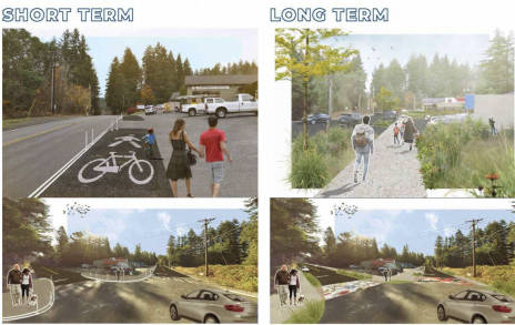
Street and path concepts for Island Center