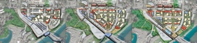
Three views of the future ferry terminal
Published 11:00 am Saturday, September 30, 2006
The area could see underground parking and more intense growth.
Washington State Ferries architect David Hewitt opened Thursday’s ferry workshop by noting the five-story dip in elevation from the corner of Ferncliff Avenue and Winslow Way to the dock below.
Then he, along with city-hired architect Rick Williams, unveiled to the more than 100 people stuffed in City Hall how designers might carve up the hillside to create a new terminal and ferry district.
In discussing one option, Williams lauded the idea of creating a flat walk from Winslow Way to the terminal.
“As you know, that’s the march of death,†said Williams to the meeting’s observers, who chuckled knowingly in response.
So began the mostly positive dialogue as, for the first time since the city and WSF began their joint march toward what they hope will be a less ominous fate, the public got a peek at preliminary designs for the $160 million project.
Three plans were presented, all of which took advantage of the natural elevation drop to incorporate underground parking, mixed-use development, more public space and better views. Improved access and circulation were top priorities, as was the need to better separate different modes of transportation.
WSF has projected a 136 percent increase in walk-on passengers at the Bainbridge terminal by 2030. That, coupled with a 25 percent increase in vehicle traffic on the route, has forced planners to key on transportation to and from the facility.
The plans sought to meld the operational needs of the ferry system with the city’s objectives for the ferry and gateway districts, which are guided by the Comprehensive Plan and Winslow Tomorrow.
Designers will incorporate ideas from the meeting into a preferred alternative, which they hope to finish by January.
There will be another public meeting in late November or early December to update progress.
Following that, the project would enter the environmental review stage before construction could begin in 2009.
One of the options presented Thursday would eliminate Harbor view Drive and create a new, two-lane road with a bridge connecting the ferry yard and condominiums to Bjune Drive. Another showed a transit loop that would swing from Cave Avenue down to the terminal before exiting at Ferncliff.
All pushed parking underground in favor of above ground development that would likely be a mixture of condominiums, retail and public space.
Under all three plans, the vehicle holding area would more than double in size to about 570 cars.
Because much of the land surrounding the terminal is privately-owned, the city and WSF still must negotiate with land owners about the possibility of developing the space.
Following presentation of the designs, the public split up into groups to dissect the plans before reporting back to the larger group.
Assessments were mixed.
Many, including island resident Christian Ford, noted that the plans failed to address traffic problems at the intersection at State Rout 305 and Winslow Way.
“I tend to prefer the pedestrian’s point of view,†he said. “When ferry traffic unloads it’s like a flash flood of cars.â€
That flood, Ford contends, inhibits pedestrian circulation between downtown and what would likely become a new commercial hub near the terminal.
“In an odd way the ferry terminal is isolated from Winslow,†he said. “They have the potential to tie this together into a complete, pedestrian-friendly urban core.â€
WSF planner Rob Berman acknowledged the omission of the intersection from the plans, saying the issue would be addressed at future meetings.
Past discussions included tunnels or overpasses that would circumvent WInslow Way, but logistical concerns – including grading – have rendered that solution less likely.
Questions about scale and character also abounded.
A large contingent of Cave Avenue residents feared that a new bus entrance across from Cave would eventually lead to rerouting traffic up the quiet street, something that could potentially “destroy†the neighborhood’s character, according to some.
Officials said there are no such plans and that the entrance would only be aligned with Cave to create a more natural intersection.
“As a culture we tend to be ambivalent about growth,†said Winslow Tomorrow Project Manager Sandy Fischer. “We generally do support growth strategies that are more compact and protect the character of neighborhoods.â€
Others were concerned that bicycle and car traffic weren’t adequately separated in any of the new plans.
Still, Williams cautioned that it was still early in the planning process.
“In 25 years of doing this I’ve never gotten it exactly right on the first try,†he said.
Now, with a notebook full of suggestions from people like Ford, designers will go back to the drawing board to prepare for the next meeting.
“This is the first time I’ve been to a planning process meeting,†Ford said. “It was a nice open process and they were desirous and eager to harvest information. I just hope that information is transferred upward to the people who make decisions.â€