Know your zones in case a wildfire breaks out
Published 1:30 am Tuesday, June 22, 2021


With summer arriving the city of Bainbridge Island is again warning residents and visitors alike about the potential for wildfires.
Over the past several summers, the air quality in the Pacific Northwest from wildfire smoke has been hazardous. The cause is a mix of several factors, including forest management and climate change. The patterns of climate change—warmer spring and summer temperatures, reduced summer precipitation, increased evaporation and increasing prevalence of pests and diseases—are projected to increase the frequency and extent of fires compared with the 20th century in the Northwest.
One such fire happened last September. A campfire that had not been fully extinguished on private property had broken out and spread due to the dry conditions. The BI Fire Department, assisted by nearby agencies, spent about 20 hours working to contain the brush fire and get it fully extinguished. Nearby families had to evacuate their homes.
If a similar incident occurred in your neighborhood, would you know what to do? Do you “know your zone” and what the types of evacuation orders mean?
This awareness is an important part of our community’s wildfire response, and emergency management officials want you to be prepared.
“It is critical for residents and businesses on Bainbridge Island to know which zone they live or work in,” said Anne LeSage, emergency management coordinator. “This is how you’ll know if any announcements we make about where fires have occurred apply to you.”
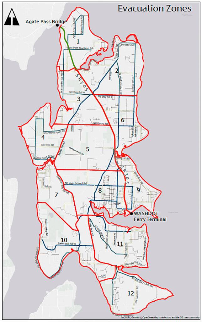
LeSage worked with the BIFD and BI Police Department in 2019 to develop the Know Your Zone program as part of the wildfire response and evacuation plan. The program divides BI into 12 evacuation zones based on general neighborhoods, main street boundaries and population.
During a BI wildfire, three types of evacuation orders may be issued:
•Prepare to evacuate: Get people, animals and emergency gear ready for evacuation.
• Voluntary evacuation: The threat to lives is not yet imminent, but dangerous conditions exist or such circumstances may exist in the near future. It is “recommended” that people relocate to a safer location.
• Mandatory evacuation: Leave immediately. There is an imminent threat to life and property. People and their pets in the mandatory evacuation order zone(s) should evacuate as soon as they receive the order.
These orders will be sent out through Nixle alerts, an emergency notification system. To register for Nixle alerts, text 98110 to 888777 or visit the Nixle website at Nixle.com.
If a zone is to be evacuated, residents will be given instructions for evacuation routes away from the hazard. They may be ordered to report to a temporary reception center or, if off-island evacuation is needed, to head north on Highway 305 to the Agate Pass Bridge or south to the ferry terminal. Traffic control points will be established as needed and assigned to law enforcement officers to maintain an orderly flow of traffic out of the affected area(s).
Traffic control personnel may be supplemented with Public Works staff and Community Emergency Response Team volunteers specifically trained in traffic management.
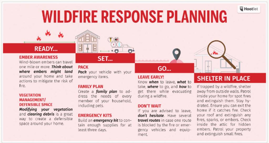
In anticipation of possible evacuation, BIFD wants families and communities to prepare evacuation plans that include predetermined meetup spots and a way to manage the evacuation of people with physical disabilities and pets and livestock. In addition, people should have “go bags” ready to grab when an evacuation order is issued.
“Waiting until the last possible moment or refusing to evacuate puts both you and our first responders in the greatest danger,” deputy fire chief Jared Moravec said. “Be prepared, know your zone and leave early if recommended to do so.”
If you cannot evacuate and must shelter in place, the BIFD recommends you stay inside away from outside walls. Patrol regularly to extinguish spot fires inside and surrounding your home. Check your roof and attic for embers. Stay hydrated and make sure you can escape your home if you need to.
Also, the BI Climate Action Plan describes several actions that could improve the big-picture situation:
• Identify infrastructure and utilities that are located in or near wildfire risk areas and protect or alter them to reduce risk.
• Evaluate and identify opportunities to improve forest health, including problems associated with stand densities (the amount of trees per acre), disease and wildfire risk.
• Work with city arborist Nick Snyder and partnering community groups to create a preferred list of tree and plant species favored by climate change projections for use in city planning and restoration efforts.
• Ensure equitable access to community hubs for emergency food/ water/filtered air during poor air quality due to wildfires.