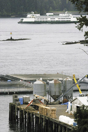
The salmon farm in Rich Passage is located on a maritime highway, but the only land access is over Fort Ward Hill Road, a narrow, winding street through a densely populated neighborhood.
So it makes sense logistically and economically to bring in food for the salmon by water, rather than land.
“Bringing in the food by barge saves costs dramatically, and mostly eliminates the big trucks going over the hill,” said Arve Mogster, on-site operations manager for Cypress Island, Inc., the present owner of the operation formerly known as Northwest Sea Farms.
Cypress wants to eliminate daily truck runs over the hill and through the Fort Ward neighborhood, replacing them with one monthly over-water barge delivery.
But if Cypress ships in a month’s worth of food, it needs a place to store it. The plan is to position two barge-top warehouses in the middle of the two groups of floating pens on the Bainbridge side if Rich Passage, with another servicing the pens on the far side of the passage.
While most of the barge would be for food storage, each would contain rest rooms, and a break-room for crews, and will have a fork-lift for moving the food.
“Right now, we offload food from a truck to the pier, then boat out to the pens,” Mogster said. “There would be a lot less handling with the barges.”
But the image of floating warehouses does not appeal to the neighbors.
“It’s going to be like looking at a battleship,” said Gordon Black of the Fort Ward Neighborhood Association. “It will be an awful lot of grey paint.”
While the battleship comparison may be an exaggeration, the barges won’t be tiny.
Those on the Bainbridge side would each be 46 feet wide. One would be 100 feet long, the other 146 feet. The barges would sit three feet out of the water, topped with 13-foot-high warehouses.
“It will be the size of six, 3,200-square-foot houses,” said architect Don Ashton, whose home on Fort Ward Hill Road overlooks the salmon farm operation.
Neighbors acknowledge that there would be some community benefit to the reduction in truck traffic, but are still not sold on the deal.
“The community needs to weigh whether the disruption of one truck per day is outweighed by the chaos of visual disruption,” Black said. “There needs to be a visual and environmental benefit to the community.”
Black said people other than neighbors should be concerned.
“Anyone who comes to Fort Ward Park will notice the large structures,” he said.
“This affects more than eight or 10 homeowners, it affects everyone who uses the park. It’s an island-wide issue.”
Cypress says the visual impact would not be as great as the neighbors fear. A consultant submitted computer-generated photos of what the pens would look like with the barges in place.
The consultants say the visual impact would be negligible, particularly from Fort Ward Hill, because the height of the barges is less noticeable from that perspective. The consultants also say that from shore, only the narrow side of the warehouses would be visible.
City planning staffer Joshua Machen tends to agree.
“I visited an operation in the Anacortes area with barge warehouses the same size, and you really don’t much notice them,” he said.
The overall visual impact can be reduced further, Cypress officials say, by moving equipment into the warehouses that is now stored visibly on the company’s pier, and by removing the three silos on the pier where fish food is now stored.
Neighbors are unmoved by that argument.
“A lot of the stuff they are offering in mitigation is stuff they should be doing anyway,” said Ashton who labeled the so-called mitigation measures as “cleanup” activities.
A better form of mitigation might be to let the public use the company’s dock, said neighbor Mary Dombrowski in a written comment on the proposal.
Mogster said he is willing to at least discuss that idea.
“I wouldn’t object,” he said, “but it would have to be in a manner that wouldn’t put anybody in danger from the operations we conduct there.”
According to South Beach Driver resident Henry Jameson, an attorney, the city’s shoreline regulations should scuttle the project.
Jameson says that under those regulations, the only activities permitted to occur seaward of the ordinary high-water mark are so-called “water-dependent activities,” defined as activities that cannot occur on land.
The fact that food has been stored on land for many years proves that it is not a “water-dependent use,” Jameson says.
The proposal cleared its first hurdle when Planning Director Stephanie Warren ruled that the project does not have a significant effect on the environment if certain mitigation measures are taken.
Cypress still needs a ruling that the plan complies with the city’s Shoreline Management Master Program, an issue that will be decided by examiner Robin Baker after a May 24 hearing.
If Warren’s finding of no significant impact is appealed, Baker will hear the appeal as part of the same proceeding.
Machen says the city may not have the final word on the dispute.
“It makes economic sense, and from everything I can tell it makes environmental sense as well,” he said. “But there’s no guarantee the state Department of Ecology will buy off on it. And there is plenty there for the lawyers to argue about.”